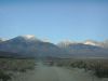
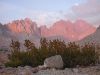
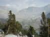
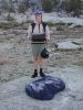
Following Skip (former Navy officer and LA Department of Water and Power surveyor, current B-and-B host and private pilot) up to the Taboose Pass trailhead, where we'll hike out on Saturday. Skip gave us a ride to our entry trailhead at South Lake. Note the early morning shadows of the Inyo Mountains on the Sierra.
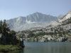
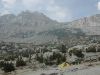
South Lake, just west of the town of Bishop, still one of our favorite trailheads.
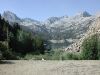
At Long Lake on the trail from South Lake up to Bishop Pass.
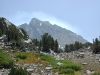
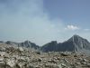
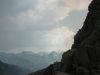
Closing in on Bishop Pass, and seeing the day's first sign of the Deer Meadows fire in the distance.
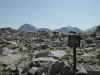
At Bishop Pass, elevation 11972'.
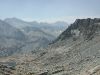
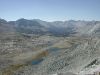
Looking from Bishop Pass toward Columbine Peak (on the right) and the Palisade Basin beyond. Hmm; that's where we want to go.
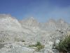
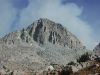
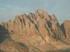
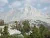
View of the North Palisade group from Dusy Basin, just over Bishop Pass. Someone once wrote "Unlike a lot of mountains in the Sierra, the Palisades actually look like mountains are supposed to."
Thunderbolt Peak and North Palisade as seen from Dusy Basin.
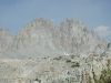
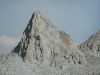
Isoceles Peak, one of the more dramatic Dusy Basin landmarks. Not quite isoceles from this point of view, however.
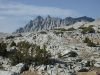
Columbine Peak, another prominent feature in Dusy Basin.
Looking back over Dusy Basin toward Bishop Pass, and the Inconsolable Range.
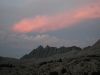
Thunderbolt, North Palisade, and Isoceles as seen from our Tuesday-night campsite. The Deer Meadows fire is making things look a little iffy.
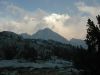
The Inconsolables in evening light.
Mount Winchell in evening light.
Evening view from our Tuesday night campsite.
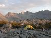
Our campsite in Dusy Basin, Tuesday evening.
More evening light on the North Palisade group.
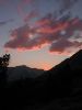
Sunset Tuesday.
Sunset clouds over the Inconsolables.
Wednesday morning, and time to leave Dusy Basin for the Palisade Basin. Little visible smoke, so maybe the Deer Meadows fire settled down during the night. Our off-trail route leads over Knapsack Pass, the saddle roughly in the center of the picture. Columbine Peak is the mass of rock on the left-hand side.
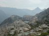
On the way up to Knapsack Pass. There's a fair amount of talus to be dealt with, but no brush (which we remember with no fondness from the different route we took the first time we went over Knapsack, years ago). About this point we met a German couple who turned out to be taking the same route we'd planned, but in the opposite direction. Their comments about the smoke from the fire (annoying, but not health-threatening) were reassuring.
Looking back from Knapsack Pass to the lower Dusy Basin lakes. In the distance is the route down from Muir Pass to the LeConte Canyon, which we visited on our trips from North Lake to South Lake.
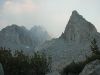
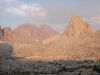
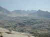
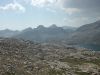
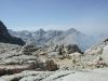
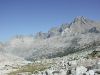
At the top of Knapsack Pass, looking into the Palisade Basin and toward the Palisade Crest in the distance. Our next major objective, Potluck Pass, is in the light-colored area that appears to be beneath the Palisade Crest.
A final close look at the North Palisade group from Knapsack Pass.
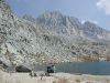

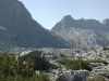
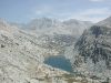
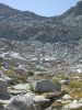
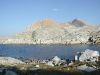
Our lunch stop on Wednesday, the second-largest of the Barrett Lakes in Palisade Basin.
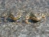
This Barrett Lake is full of frogs! Big groups of them clustered at the waterline, and enormous tadpoles in the water. We were really pleased to see them, because in our experience Sierra frogs have been growing scarce in the last 15 years. Another hiker told us that trout eat tadpoles, so there may be a tendency for the frogs to disappear wherever lakes are stocked with trout.
A particularly photogenic pair.
Looking back from Potluck Pass. The upper Barrett Lake is on the right, and Knapsack Pass is the low point in the spur that runs behind the lake. Some interesting clouds beginning to develop at the upper right...
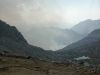
Looking down from Potluck Pass toward Deer Meadow. This is one of our closest approaches to the fire. The combined John Muir and Pacific Crest Trails run in the canyon below us, directly through the fire zone.
Looking south from Potluck Pass.
Michelle descending from Potluck Pass into the Glacier Creek basin, our home for Wednesday night. The unnamed lake in the photo is the source of the creek. Visible as the low point in the spur behind the lake is Cirque Pass, our first goal for Thursday.
Michelle looking at the smoke from the Deer Meadows fire at the bottom of the Glacier Creek drainage.
Allen starting down from Potluck Pass. Unfortunately, it was about this time that those "interesting" clouds in the background began to snow! So we hustled down to the lake, made camp, wolfed dinner, and crept into the tent to stay warm. Didn't have time to take pictures.
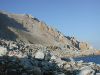
A look at Potluck Pass from the bottom, in the fresh light of Thursday morning. (We angled left on the rock, then slid down the sandy patch on the left-hand side.)
A look across the lake to our first objective for the day, Cirque Pass. Cirque was reputed to be the most difficult of our three off-trail passes, and was the only one of the three that we hadn't crossed before, so we were a little apprehensive.
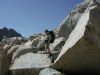
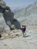
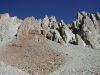
The way up Cirque Pass turned out not to be so bad. We worked our way up mostly-easy ledges to a gravelly chute which was all class 2 except for two very short class 3 pitches. Here's Allen on the last stretch near the top.
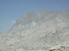
Thursday morning had been virtually smoke-free, but by the time we made it up Cirque Pass the Deer Meadows fire was awake again.
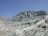
The unnamed lake and headwall of the Glacier Creek basin.
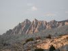
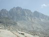
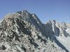
The Palisade Crest. Many years ago we tried an ambitious (for us) trip involving an off-trail crossing of the Sierra crest. (And also a hitchhiking excursion back to our car, but that's a long story.) The crossing point was Scimitar Pass, and you can see the approach to it (the actual pass is around the corner) as the low saddle at the left end of the crest. We took a very hard look at it on this trip. It appears to be class 3+ from a distance, though the infamously generous guidebook we used on the earlier trip calls it class 2 and we remember it as class 2-3. Don't know how we found the right route last time.
Michelle scaling the last slab on the way to the top of Cirque Pass.
We bid a hazy farewell to the North Palisade group, and Potluck Pass at the left.
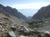
Our first look at the descent from Cirque Pass. The lake at lower left served as our lunch spot for Thursday.
The descent from Cirque Pass required two stages. Here we've completed the first, and gained a view of the Palisade Lakes. All we have to do is get down there, and we can rejoin the trail.
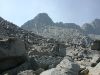
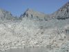
Getting down the second stage of Cirque Pass proves more difficult than the first. We think the little lake shown here is along the route we should have taken. Instead we took a more direct route that turned out to involve climbing down talus - not one of our favorite activities.
Eventually we did clamber down to the two Palisade Lakes, and this photo shows the lower of the lakes. [Judging from the angle of the lake, I must have been a little oxygen-deprived when I took this one - Allen] Here we met a man and his son who were trying to decide if they could get their train of five llamas through the fire zone, which is some miles behind us.
We camped at a waterfall in an inlet stream above the upper Palisade Lake. Mt. Bolton Brown is above us.
As we settle in for Thursday night, we get a look at Friday's first goal, Mather Pass, from our campsite. The pass is the low point left of center.
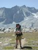
Allen in camp on Thursday night.
Evening falling on Mt. Bolton Brown.
Friday morning frost on the bear-proof food can and on Allen's pack.
A nice view of the Palisade Lakes area as we walk up the John Muir trail to Mather Pass. It's a little hard to point out without marking up the photo, but Cirque Pass is visible near the left end of the ridge.
On the way up to Mather Pass. Looks bad, but actually was an excellent trail: well-designed and well-maintained. It was around this point that we met a guy who had been in the last group of hikers escorted through the Deer Meadows fire by a crew of rangers. He told a harrowing tale of trees exploding into flame, and running through fallen logs to get past the worst of the fire zone. No wonder Kings Canyon decided to close that part of the trail.
The unnamed peaks west of Mather Pass.
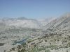
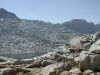
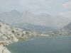
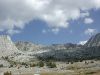
Our first look from Mather Pass at the Upper Basin of the South Fork Kings River, west of Split Mountain. We decided that this was definitely one of our favorite places on the trip.
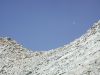
Moon setting over Mather Pass.
Michelle walking through the Kings River Upper Basin.
Allen in the Kings River Upper Basin.
Fall is near - the groundcover is beginning to turn red.
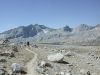
On the trail up to Taboose Pass, our Friday-night (and final) campsite.
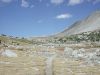
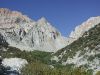
Nice-looking territory south of Taboose Pass.
Last pass for the trip.
View from our campsite next to one of the small lakes at the top of Taboose Pass.
View across the lake from our campsite at Taboose Pass.
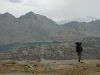
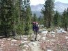
Heading down the trail from Taboose Pass on Saturday morning, with the Inyo Mountains silhouetted in the background. The Taboose Pass trail has a reputation as a killer, because it starts at relatively low altitude in the desert and runs up 6000' to the pass. We found it suprisingly nice, well-maintained with stretches of rock, sand, and big trees shading a rushing stream. However, we're very glad we were hiking down.
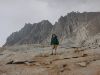
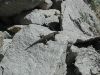
Rocks and scree near the Taboose Pass trail.
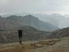
Looking back up toward Taboose Pass.
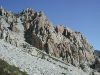
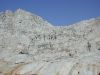
Rock formations on the Taboose Pass trail.
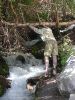
A local resident.
6000' down in one morning is hard on your feet. Here Allen is about to cool his heels in Taboose Creek.
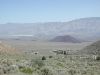
The last stretch of trail before we reach the car we left behind what-seems-like so long ago. Owens Valley in the midground, with one of the Big Pine lava flows partly visible. From here it's off to the showers at the Big Pine Texaco Truck Stop, up to the Tioga Gas Mart for early dinner at Tioga Toomey's Whoa Nellie Deli, and back to Palo Alto.